Our forecast for today, from yesterday, was pretty accurate for the most part. Today's high was 29F at 2:05pm when conditions were mostly cloudy.
Current conditions at 5:30pm are at 28F and we are still experiencing overcast conditions. Humidity is at 51F, with a dew point of 12F. Winds are coming from the NW at 14 mph, creating a wind chill of 17F. The wind chill is chilly because winds coming from the NW are bringing in cold, dry continental air from the arctic region. Currently there are no low pressure systems in our area so we don't have to worry about precipitation of any kind.
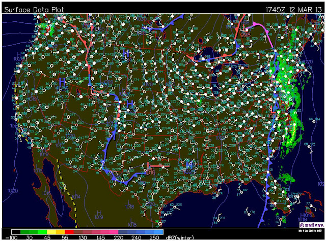
We can see from the surface map below that the low pressure systems have moved their way east. Radar on the map shows the the east coast is experiencing precipitation in the form of rain. This is due to warm, moist air coming in from the Atlantic and getting lifted by the cold front that is coming in behind it. This lifting causes condensation and precipitation. We can also see a stationary front in the west. This is due to the Rocky Mountains acting like a dam.
The forecast for tonight calls for a low of 12F. There is an 80% chancce of precipitation in the form of snow is expected before midnight. Snow accumulation is expected to be less than 1/2 inch.
Tomorrow's forecast calls for mostly sunny skies and a high near 30F. Winds will continue to come from the NW around 10 mph.


No comments:
Post a Comment