Friday, March 29, 2013

Last nice day before the wet Easter weekend

Well today was another nice day, just as we expected. The surfacea map below we can see the high pressure system still located near us which is the cause for this nice weather.Today's high reached up to 45F.


Current tempertures are at 45F. Humidity is at 37%, with a dew point of 20F. Winds are coming from the south around 5 mph. We know what south winds indicate...precipitation, and that is in the forecast for this easter weekend.


Again, taking another look at the surface map compared to the jet stream map we can see that the the low pressure system located near southwestern South Dakota is moving it's way over to us. The low pressure system combined with warm, moist air coming from the south will create wet weather conditions.


Tonight's forecast calls for a 60% chance of precipitation in the form of rain. Good thing it's rain and not snow. Hopefully it will help get rid of some of the snow!

Tomorrow's forecast calls for a 80% chance of precipitation in the form of rain before 4pm.

Thursday, March 28, 2013

Nice weather due to the high pressure system moving in

As we discussed last time the high pressure system that was located near southern Minnesota has moved much closer to western Wisconsin. This is causing mostly clear skies, allowing the sun to beat down and warm us up!

Today's high is forecasted to reach 44F. The current temperature is at 18F, and feels like 18F. Winds are calm coming in from the SW around 5 mph. Normally winds coming fromt he SW would indicate some sort of precipitation. However, because we have a high pressure system near us there is no need to worry. The barometric pressure is currently at 30.32in. Humidity is at 88%, with a dew point of 14F.


This nice weather is expected to continue through tomorrow with highs in the 40's, possibly reaching the 50's.

Then comes easter weekend. Yayayayayay for easter! The word just makes you feel spring. However, not this easter weekend. A low pressure system is forecasted to move in Saturday morning creating precipitation throughout the weekend. BOOOOOO!!! We'll stay updated on this low pressure system and see what it does to the snow on the ground. Will there be more of less of it?? Guess we'll have to wait and see.

Tuesday, March 26, 2013

High 30's with a hopeful push into the 40's by the end of the week

It's staying in the high 30's just like we predicted from yesterday!

Today's high is 37F. Current temperatures are at 37F, but it feels like 32F due to the cloud cover. We can see from the surface map that western WI is experiencing overcast for the day. Wind is coming from the NW around 6 mph. Skies are expected to break up throughout the afternoon allowing more sunshine to shine through. Today's humidity is at 52%, with a dew point of 21F.


Tonight's forecast calls for  a low of 19F, with skies continuing to be partly cloudy. Winds will continue to come from the NW around 5 mph.

Tomorrow's forecast calls for partly sunny skies with a high of 36F. Looking at the surface map below we can see a high pressure system hanging out right at the edge of southern MN. This high pressure system is expected to move in over WI by tomorrow. This will be happening because winds will continue to come from the NW, and the jet stream is moving in the correct directional movement as well to influence this migration of the pressure system. 


Monday, March 25, 2013

Great weather for the week!

Hi everyone! Sorry I've been gone for a while. It was spring break last week, so you know what that means...midterms the week before then time to let loose and recuperate from the crazy semester. I did check in on the weather periodically last week. I don't have any images to show you from then, but I can tell you that we did get precipitation in the form of snow last Monday. I checked the surface map and we had a low pressure system over us bringing with it winds from the east. As we already have talked about winds coming from the east are being fed with moisture from the ocean. Once the warm, moist air rises high enough it cools  and eventually cools to it's dew point where it condenses and forms precipitation. That was the only day we had precipiation. The rest of the week was chilly.  Morning temperatures ranged between -10 and 10, but warmed up around the 20's and 30's in the afternoon.

This week is forecasted to have clear skies, with temperatures warming up to the high 30's and into the 40's. This will cause a lot of the snow we have to melt!! YAYAYAY!!! Hopefully the ground warms up enough so a lot of the water asborbs into the ground for a good crop growing season.

Today is forecasted to have a high around 36F. The current temperature is at 21F and feels like 21F. Humidity is at 74%, with a dew point of 14F. Skies are clear with winds are coming from the NW around 10-15 mph. Again, we know that winds coming from the NW won't produce any precipitation because they are being fed by cold, dry polar and artic air masses.


Weather conditions to the southeast of us aren't quite as good as they are here. We can see a low pressure cell located over Ohio. Again, winds circulate counterclockwise around low pressure systems. This is bring cold, dry air down from the polar/arctic regions and going underneath the warm, moist air coming in from the Atlantic. We know this will raise the warm, moist and cause precipitation. The surface map shows a lot of precipitation in the form of rain in this region. The low pressure cell located in the Atlantic is also contributing the a lot of the moisture in the atmosphere at this time.


Thursday, March 14, 2013

Crappy crappy forecast outlook...I'm sorry...

Well the forecast was right. We are getting a little bit of snow today. However, we haven't received the freezing drizzle that was expected before 2:00pm today. I guess it's only 12:15pm so there is still time. The forecast for today does call for a chance of snow, freezing rain, and sleet after 4:00pm today...icky! Looking at the surface map below we can see a low pressure system located near southwestern Minnesota. As we've said many times in the past low pressure systems indicate rain due to the system containing warm, moist air.


When looking at the wind patterns we can see that the wind is coming from the southeast. A big red red flag should go off whenever you see wind coming this direction, or from the southwest or east for that matter. This is because wind coming from the SE is filled with moisture from the Gulf (you can see this being pulled up from the Gulf by looking at the wind map). 


Looking at the jet stream we can see cold, dry air being pulled down from the north. Combining the cold air with warm air and the low pressure system we can understand why we are having the nasty bit of weather we are having today.


Today's high is expected to reach 34F. Current temperatures are at 36F with overcast. Humidity is at 81% with a dewpoint is at 21F. Barometric pressure is at 30.14 inches. As we know winds are currently coming from the SE at 8 mph, but are expected to shift to the SW later this afternoon. SW winds still imply precipiation because the cold air coming counterclockwise around the low pressure system will be colder from the NW and will lift the warm air ahead of it still creating precipitation. This makes sense since there is a chance of snow, freezing rain, and sleet after 4:00pm.

Tonight's low is forecasted to be 24F and cloudy. Winds are expected to continue to shift with winds coming from the W around 5 mph. Winds coming from the west imply better weather conditions.

Tomorrow all forms of precipitation are expected to form only snow after 1:oopm with a high of 37F. Winds are forecasted to shift back to the E tomorrow afternoon...darn it! There is a 90% chance of precipitation due to this shift. Ice accumulation is forecasted to be less than 0.1 inch and with new snow and sleet accumulation of 2-4 inches is possible.


Wednesday, March 13, 2013

Clear skies and sunshine!

Today ended up being a nice like was forecasted. The high was 30F at 2:45pm with clear, sunny skies. Now the temperature is 27F at 7:30pm. Humidity was 43% with a dew point of 7F. Looking at the surface map we can see a high pressure system located near Wisconsin. This is the cause of a barometric pressure of 30.27 in. As we have discussed before high pressure cells and high barometric pressure indicate clear skies and fair weather; both of which we have been experiencing today.


These clear conditions could also be contributed to the cold, dry arctic air we are receiving from the jet stream.


Today's wind direction is coming from the W at 6 mph. This is a shift from the NW winds we had yesterday.


Tonight's forecast calls for a low of 15F with increasing cloud cover. Wind direction is expected to shift to the S after midnight.

Tomorrow's forecast is expected to reach a high near 32F. There is a chance of snow, then freezing drizzle before 2pm tomorrow. With that, winds are expected to be coming from the SE. The SE winds will be the cause of this precipitation because it will feed in moisture from the Gulf. Winds are expected to shift back to the SW later in the day. Total snow accumulation is forecasted to be 1 to 2 inches with now ice accumulation.

I don't even know if I should bring this up, but knock on wood it doesn't hit too hard. Rumor is that there is another winter storm forecasted for next week. As of now the models for this storm are inconsistent, but if it goes as currently modeled we could expect several inches of snow.

I realize more snow would benefit the agricultural growing season due to the drought we've had the last few years, but the snow has been so thick and wet. Aaaahhhhhh it's no fun driving and walking in!!  


Tuesday, March 12, 2013

No snow today!! Yayayay!!

Our forecast for today, from yesterday, was pretty accurate for the most part. Today's high was 29F at 2:05pm when conditions were mostly cloudy.

Current conditions at 5:30pm are at 28F and we are still experiencing overcast conditions. Humidity is at 51F, with a dew point of 12F. Winds are coming from the NW at 14 mph, creating a wind chill of 17F. The wind chill is chilly because winds coming from the NW are bringing in cold, dry continental air from the arctic region. Currently there are no low pressure systems in our area so we don't have to worry about precipitation of any kind.


We can see from the surface map below that the low pressure systems have moved their way east. Radar on the map shows the the east coast is experiencing precipitation in the form of rain. This is due to warm, moist air coming in from the Atlantic and getting lifted by the cold front that is coming in behind it. This lifting causes condensation and precipitation. We can also see a stationary front in the west. This is due to the Rocky Mountains acting like a dam.


The forecast for tonight calls for a low of 12F. There is an 80% chancce of precipitation in the form of snow is expected before midnight. Snow accumulation is expected to be less than 1/2 inch.

Tomorrow's forecast calls for mostly sunny skies and a high near 30F. Winds will continue to come from the NW around 10 mph.


Monday, March 11, 2013

Winter Storn Triton hasn't been nice to us

Well I was wrong about saying that the storm moving in over the weekend wasn't going to be too bad. We were in a winter storm from Saturday till noon today. After today's snowfall the Eau Claire area is expected to have a total of 8 inches of snow accumulation. With that 8 inches added to the snow accumulation we had the previous week there is a total of 14 inches on the ground. We can see from the surface map below that the low pressure system has moved over Michigan at this point. We can also see the cold and warm front associated with this systems, and the resulting precipitation in the form of rain ahead of the cold front. We are still experiencing bits of precipitation in the form of snow in our region. Looking at the wind surface data map and the wind map below we can see that this is probably due to the NE winds that are pulling warm, moist air over lake superior and into Wisconsin where it's running into cool, dry air. 


Today's high was 32F at 1:05pm, with overcast cloud cover.


Tonight's forecast calls for a low of 19F with overcast cloud cover. Winds will be coming from the W around 5-10 mph.

Tomorrow's forecast calls for a high of 30F, with winds coming from the NW around 10-15 mph. There is 60% chance of precipitation in the form of snow, with an accumulation of less than 1 inch.


Wednesday, March 6, 2013

Nice day due a high pressure systems

Today high was 29F with clear skies and sunshine! With this beautiful day and March's sun able came a lot of snow melt. This is nice because the roads are finally clear, for the most part. But, the sidewalks are all full of water puddles and that isn't any fun.

Current conditions include a tempertaure of 28F. Humidity is at 53%, with a dew point of 13F. Looking at the surface map here we can see that skies are clear, with wind coming from the N around 7 mph. The barometric reading is at 30.29". Together all these conditions make sense since there is a high pressure cell in northern Iowa. Typically, high pressure cells are associated with clear skies and nice weather.


Here are the current wind conditions. We can definitely see that nothing major is taking place in our region of the U.S. However, we can see winds patterns are much stronger in the west and on the east coast. If you take a look at the surface map above you can see that there are some low pressure systems in these regions causing this.


This is a picture I took of the sky looking south from my house. Here we can see a small amount of cirrus clouds. About 30 minutes before I took this picture there were no clouds located in this area, they were only to the north and west. By comapring the movement of the clouds to the wind and surface map, these patterns make complete sense. These cirrus clouds also indicate fair to pleasant weather.


After seeing the strong winds patterns from the wind map and noticing the low pressure cells on the surface map I thought it would only be appropriate to take a look at these conditions. The surface map below shows high pressure cells going up through the plains area. As we already discussed, this makes complete sense with our current weather conditions and wind patterns. We see a few low pressure cells in the west which is causing the crazy weather patterns we're seeing in this region, due to the Rocky Mountains. We also see a low pressure cell located off the east coast, with radar indicating light to moderate rain in these areas. That poor east coast is really getting hit hard this year. I'm glad I'm not there, it makes me appreciated Wisconsin's weather a bit more.  


I couldn't help myself but to check out the water vapor in these regions after seeing all these other factors. Oh yeah, check out the water vapor swirling counterclockwise into the coastal land from the ocean. This is from water evaporating into the atmosphere from the ocean. Once this warm, saturated air hits land it rises over cooler drier and eventually condenses creating precipitation. This time it's in the form of rain instead of snow though. I bet they're happy about that.


Temps are forecasted to rise the rest of the week, possibly up to about 40F by Friday. We are expecting another storm system is expected to hit on Saturday. This time precipitation is forecasted to be in the form of rain instead of snow though. It shouldn't be too bad.


Tuesday, March 5, 2013

The winter storm proved to be not too bad

Well, the snowfall accumulation for this winter storm wasn't quite as bad as expected. The image below is a picture I took on my way home from school around 10:00am this morning. Here we can see stratus clouds, I believe they are altostratus clouds. The reason I think they are altostratus is because they are they are covering the entire sky, and contain continuous snow at this time. Icky, icky, icky!


This is an image I took around 5:00pm. By this time most of the snowfall has stopped. Overall, a total accumulation of 5.3" was recorded at 3:00pm in Eau Claire. For scale, we can see that my hose, that never got put away for the winter, is almost 3/4 of the way covered in snow accumulation.


Current weather conditions include a temperature of 26.2F, but it feels like 20.3F. Relative humidity is at 94%, with a dew point of 24.6F. Barometric reading is at 30.13 in Hg and rising rapidly. Winds are coming from the north at 7 mph.

This surface map, that I obtained around 5:30, shows wind direction coming from the north around 7mph. The winter storm warning was in effect until 6:oo pm. However, winds coming from the north no longer have moisture feeding into them, therefore there is no more moisture coming into condense and turn into precipitation. 


We can conclude from both the wind direction and barometric pressure that conditions will clear up very soon. As I stated above, winds coming from the north no longer have moisture feeding into them. Also, the rapidly rising barometric pressure indicates high atmospheric pressure. This means the low pressures are moving out, which indicate precipiation; and high pressures moving in, which indicate clear skies, because of a lack of moisture.

Here is an illustration of wind patterns at this time as well. Here we can confirm winds are coming from the north. Like I stated above, these winds coming from the north no longer are being fed with moisture. These winds are coming from the polar region which contain cold, dry air that will lead to weather conditions void of precipitation.


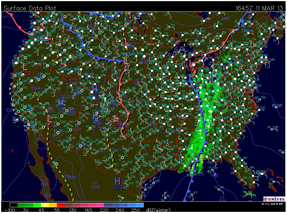
This surface data map shows that the low pressure cell has moved to the southeast, and there is precipitation in the form of rainfall in the eastern part of the cell. As we can see this from this surface map, knowing that high pressure move into low pressure in a counterclockwise motion, precipitation is being fed into the this system from the Atlantic. We can see a warm front moving in that will continue to produce precipitation.


This surface map below depicts a close up of Winter Storm Saturn on the East Coast.


Monday, March 4, 2013

Look out! Here comes some more snow...and a lot of it!

The weekend provided us with nice weather. Temps were around the 30's and there was no precipitation of any form.

However, there is another winter storm moving thought the central plains. This storm could possibly be the largest storm in March since 2005!

Current conditions in the Eau Claire area include a high of 29F. Winds are coming from the SE around 10-15 mph, with a wind chill of 16F. Currently the skies are overcast. Humidity is at 44% with a dew point of 7F. Current barometer readings are at 30.04 in, which indicates cool, dry, heavy air with no precipitation.


What's happening with this winter storm is that there is a low pressure cell located in N Dakota. With this low pressure cell we see an occluded front. This basically means that the cold front has caught up to the warm front, and this cold, dry air doesn't like the warm moist air it's running into; causing this snowfall.


When comparing this wind map to the surface map above we can see the cold, dry air from Canada coming down into the plains region. We can also see the warm, moist air from the Gulf of Mexico coming up to the low pressure system. This is where the two different air masses are mixing and creating precipitation.


This 12 hour surface map forecast show the low moving southeast. This will cause more snowfall and accumulation in our region throughout the night time hours. Tonight's low is forecasted to be 22F. Winds will continue to come from the SE around 10 mph. There is 100% chance of snow, with an accumulation of around 3-5 inches overnight.


Tomorrow's forecast calls for a high of 26F. Winds will be coming from the N around 5-10 mph. Again, there is a 100% chance of precipitaion in the form of snow, with expected accumulation of 3-7 inches possible.


It will be interesting to see how much snow we actually get and how the roads are in the morning. Total snowfall accumulation in the regions I reside and go to school are 8-10in and 4-8in. However, our professor is predicting a possible accumlation of up to 13+ inches.


Yay Wisconsin!!!