Tuesday, May 7, 2013

Another nice day in the Valley!!! Hopefully all the snow will be gone after today!!

Today's forecast calls for a high of 79F. The current temperature is at 44F with clear suuny skies. Humidity is at 89% with a dew point of 44F. Winds will remain calm for the day coming from the S around 0-5 mph. Normally we would expect some form of precipitation with a south wind. However, because we have high pressure systems located near us and no merging jet streams over us we can expect clear skies for the day.


Monday, May 6, 2013

The high pressure system is allowing our region to warm up!!


It's been warmning up in our region the last couple days. Last week we experienced a pretty intense precipitation event in the form of wet, heavy snowfall. This was due to the jet stream pattern. Cold air was being brought down from north and warm air was being brought up from the south. The colliding of those two air masses proved wicked for our region.

As of yesterday, weather conditions have been warming up. Yesterday's high was 67F with partly cloudy skies.

Today is even warmer with the high reaching 73F and feeling like 73F. Todays humidity is at 23% with a dew point of 33F. Wind is coming from the WNW at 2mph. The barometric reading is at 33.05 in. Looking at the surface map below we can see conditions are due to the high pressure system located in MN. A high pressure system indicates clear skies and no forms of precipitation. This is creating clear skies that are allowing the solar raditation to warm us up.
 

Looking at the jet stream map we can see we are no longer in the midst of the colliding air masses we were under last week.


Tomorrow is forecasted to be another nice day with sunny skies and highs around 73F!

Tuesday, April 30, 2013

OMG!!! The weekend was soooo nice and has through today....but.....it's WI...soooo you never know what's around the corner

It's sure been warming up outside!! YIPPY!! Today's high is expected to reach 75F. The current temperature is at 70F and feels like 70F. Humidity is at 66%, with a dew point of 57F. The barometric pressure is at 29.51in. Well seems like a pretty nice day...right?  Well, looking at the barometric pressure we can see that's it's down in the 29's which indicates low pressure moving in, and as we know low pressure indicates stormy conditions.

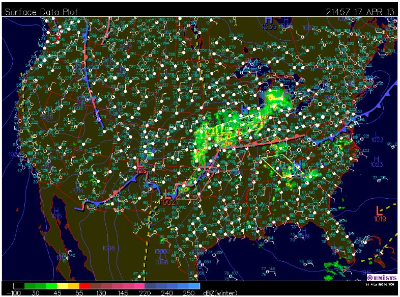
Looking at the surface map we can see a low pressure system located in northern MN with a cold front moving in throught the center of MN. Also, looking at the wind map below the surface map we can see winds are moving into WI from the S. By looking at both of these we know we have precipitation moving in. This is because a cold front has cold air coming in from behind and warm air in front of it. We already know this will cause the warm air to rise and condense, creating precipitation of some sort. However, seeing that wind is coming in from the S, with some strenght might I add, we also know there is a lot of moisture being fed to the N. The two of these combined will create wet conditions for our region today.


Looking at the water vapor map below we can see where all of this moisture is located. By comparing the cold front line in the surface map with this map we can what is known as the squall line. This is the line where the moisture is located in relation to the cold front.


When looking at the jet stream map below we can also see how these conditions are being fed. We can see a trough located in the northwestern portion of the states. This bringing in cold air from the north. The rest of the states are being fed warm jet stream air from the tropics. These two components are contributing the the difference in wind temperature, which is playing a role in the precipipation and temperature conditions.


As we just stated the jet stream conditions, as well as the wind directions conditions are all playing a role in the severe temperature gradient we are seeing below. Notice that the change in temperature is taking place where the two jet streams are meeting, the cold front is located, and the wind directions are colliding. It's not a coincident...this is how it all works together.  


The rest of the afternoon is forecasted to be a windy day with early showers and scattered thunderstorms in the afternoon. Later today winds will shift the SW leaving the evening with overcast conditions and rain showers.

By tomorrow all our nice weather is forecasted to go down the drain. Tomorrow's high is only forecasted for 45F with winds coming from the N and an 80% chance of rainshowers. BOOOOO!!!!  


Tuesday, April 23, 2013

YAYAY...A high pressure system is moving in to create nice conditions for warm temperatures later this week

We did end up receiving about 1 inch in snowfall accumulation last night.

Today's high was 43F. The current temperature is at 39F, but feels like 33F. Today's winds are coming from the NW around Humidity is at 46%, with a dew point of 20F, and a barometric pressure  mph.  Today's barometric reading is at 30.01. Looking at the surface map below we can see that the low pressure systems that were located in the west yesterday have worked their way to the Midwest. We can also see that there is a cold front associated with these fronts, as well as a line of thunderstorms.


Looking at the jet stream map we can see where the two air jet streams are merging. This matches quite well with both the cold front on the surface map, as well as the wind and temperature maps below. The jet  stream map shows where air masses with significant differences in temperature are colliding.  In the Midwest, especially, we can see where the polar and tropical jet stream air masses  are merging.

Again, looking at the wind map we can see where this cold fronts is located. We can determine this by looking at the line like feature that is associated with a change in wind direction.

Looking at the temperature map, again, we can see how the current temperatures correlate with both the high and low pressure systems, the wind map, and the jet stream. We can see where there is a dramatic difference in the temperature gradient change. When comparing this to the surface, jet stream, and wind map we can see the influences all these factors play on the temperature of a given area.


Tonight's forecast calls for a low of 25F, with winds continuing to come from the NW around 10 mph.

Monday, April 22, 2013

Dodie dodie dodie...still icky outside...sad...

Well the weather still isn't being nice to us :( It's the middle of April and everyone is getting a mad case of spring fever. Yesterday's high reached 48F at 4:45pm. Winds were coming from the SSE around 20 mph. Because of this we received a lot a snowfall in before noon. However, by the end of the afternoon most of the snow was melted due to warming temperatures.

Today's high reached 45F at noon, but the current temperature is at 41F and feels like 35F. Winds are coming from the NW around 10 mph. Today's humidity is at 93% with a dew point of 38F. These wind direction and humidity level are causing overcast and drizzly conditions.


The surface map shows a cold front in the upper midwest, going right through the middle of Wisconsin. This is bringing cold air into our region and is also a culprit for the rainy conditions were experiencing today.


 Looking at the wind map we can see right where this cold front is located with an extreme change in wind direction.

 This a also shows going in to the temperature map. we can see a line of a dramatic change in temperature right where the cold front is located.


For the remainder of the afternoon we are expecting precipitation in form of rainfall, with an accumlation between a tenth and a quarter of an inch. After 11 pm we are expecting a mix between rain and snow, with a possible snow accumulation of 1-3 inches. 


Tomorrow's forecast calls for a high around 43F and overcast skies. Winds will shift and will be coming from the NNW around 10-20 mph. 

Wednesday, April 17, 2013

Will spring ever come?!?!

Well the last two days have had decent weather compared to the rest of this season. Yesterday was exceptionally nice! Yesterday's high was 44F and everyone was outside walking their dogs!! Felt like spring was on it's way.

Today's high was 42F, with the current temperature at 41F. Humidity is at 65%, with a dew point of 30F. Here we can see a low pressure system located just north of Oklahoma. We can see a warm front moving up and a stationary front in northern Texas.


Looking at the jet stream map we can see where the two air masses are coming together. We can also see that this is where the precipitation is taking place.


With this we can see that winds are coming from the NE around 10-15 mph, with overcast. Today we experienced precipitation in the form light rain in the afternoon hours. This is to be expected as we know that winds coming from the east carry moist, warm air. Also the jet stream is colliding with adjacent air masses; all of which are causing precipitation.


Tonight's wind, as well as tomorrow's wind will continue to come from the NE around 10-15 mph. This will continue to being precipitation in the form of rain. Tonight we are forecasted to have rain with a possibility of thunderstorms before midnight, with a low around 36F. Tomorrow we are also forecasting rain with a high near 40F. 


Sunday, April 14, 2013

What is it with all this snow?!?!?!

Well, Thursday night into Friday's snow fall accumulation was as bad as expected. I don't have exact snow fall totals, but I think Wednesday was ickier than Friday.

Yesterday's weather conditions were fair. We experienced some light snow fall in the am, with no snowfall accumulation reported. Yesterday's high was 36F, with winds coming from the WNW around 16 mph with gusting around 19 mph.

However, I can't say that today's weather conditions are as nice as yesterday's. Today we are experiencing another winter storm...boooooo! It's really nasty outside! Today's high 41F. The current temperature is at 31F, but feels like 21F. Humidity is at 88%, with a dew point of 27F. We can see that there is a very low dew point depression today. The barometer reading is at 29.53 inches. Taking a look at the surface map below we can see low pressure systems located all throughout the Midwest and west, with high pressure systems in the east. The low pressure system located in the center of the states is causing the winter storm we're experiencing today.


 Today's wind is coming from the E around 13 mph. These E winds are bring in a lot of warm, moist air from the ocean causing the precipitation and overcast conditions.


I provided a Doppler radar map to show areas experiencing precipitation, as well as the type of precipitation.


The snow is supposed to tapper of around 1:00 pm this afternoon turning into rain after that. Total snowfall accumulation for today is expected to be about 1 to 2 inches. I personally think we have more than that already.

Tonight's forecast call for rain and thunderstorms before midnight with winds shifting to the southeast. After midnight winds are expected to shift to the southwest. This shift in winds should produce dry conditions for tomorrow.