Thursday, February 28, 2013

Nothing too exciting today

The snowfall accumulation from last wasn't bad. There wasn't even any snow on the roads this morning.

Today's weather forecast is fairly boring; which is fine, it's better than a ton of snow.
Today high is 30F, with humidity at 64%, and a dew point of 19F. Looking at the surface map we can see overcast,  and winds coming from the NNE around 10-20 mph, with a wind chill of 22F. We can also see that the low pressure cells have moved more to the east since yesterday. The cold front from these systems is located all the way out in the Atlantic by now.


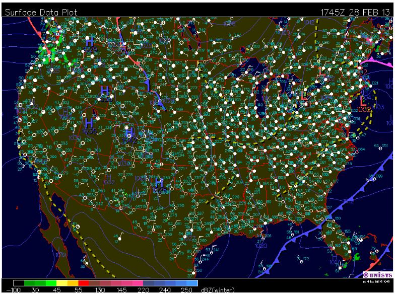
The jet stream map shows that winds are following a linear pattern throughout the southern parts of the states. We can also see that the cold cP winds from Canada are coming down throught the middle of the states and the cold air is pushing into the Atlantic as well.


We can see the overall wind movement at the surface due to the low pressure cells and jet stream patterns. We are experiencing decent winds compared the rest of the states


This water vapor map illustrates the water vapor in the air form the low pressure cells in the northeast. We have slight water vapor over us. The forecast says that light snow falls are possible due to these conditions; however, I don't think we will be experiencing any sort of precipitation today. 


Tonight's forecast calls for a low around 17F, with mostly cloudy skies and NNE winds around 5-10 mph.

Tomorrown's forecast looks relatively same as today's. The high is expected to be around 29F, with partly sunny skies, and NNE winds around 10 mph. 


Wednesday, February 27, 2013

Just a little itty bit of snow this time

As we expected there was no form of precipitation or harsh weather of any kind over last night's hours. Today' high was 36 F. The current temperature is 34F at 4:25pm, with winds coming from the north around 22 mph. It is currently cloudy and we are expecting light precipitation in the form of snow during the day time hours. Total snow accumulation is less than 1 inch.

If you take a look at the surface map you can see low pressure cells throughout the country. However, the ones located in the north and northeast are the ones having the greatest impact on our region. Cold, dry continental is moving down from Canada and wrapping itself counterclockwise around these low pressure cells.  


Now taking a look at this wind map we can see that the wind we are receiving are coming from the north, which is a direct result of these low pressure cells in the north and north east regions. Condensation is taking place over much of the north and north east regions because the warm, moist air from the Atlantic is going up and over the cold, dry air masses.


Tonight's forecast calls for a light chance of snow before 11pm, then a chance of flurries. The total amount of snow accumulation is expected to stay below 1/2 inch.

Tuesday, February 26, 2013

Nice, but cloudy due to another winter storm

Overall, the weather in our region has been consistent and nice, and is expected to stay that way. Today's forecast calls for a high around 36F this afternoon, with mostly cloudy skies. Winds are coming from the NE around 10-15 mph.

However, just because it's been nice in our region doesn't mean it's been nice in others. Currently, there is a larger winter storm moving over the country. In the surface map below we can see a low pressure cell located in southern Illinois. The cold front is located in the eastern part of the states, with a low front ahead of it. The occluded front indicates the cold front is catching up and taking over the warm front. The radar shows precipitation occuring on the east coast, as well as in norther Iowa and southern Michigan.


The jet stream map shows the cold polar air masses moving throughout the county; with a trough located in the souther parts of the states and a ridge in the north central parts of the states.


The wind map below illustrates strong wind patterns associated with the low pressure cell. We can see this by looking at the counterclockwise movement of the wind south of Wisconsin. It is these wind patterns coming from the NE that are the result of our cloudy skies.


Tonight's forecast calls for cloudy skies with a low of around 26F. Winds will continue to come in from the NE around 15 mph.

Monday, February 25, 2013

The snow's melting!

So Winter Storm Q finally hit hard at the end of last week. The image below depicts the amount of snowfall we ended getting between February 20 and the 22. From the looks of it we got around 6-8 inches or so. I really can't complain about this snowfall too much though. It was light and pretty. It really didn't make commuting too difficult.


This past weekend was beautiful outside! Yesterday was warm and sunny! When you walked outside it sounded like it was raining because so much snow was melting.

Today's high will be around 31 F, and feel like 31 F, with a winds between 0-4 mph. We can see from the surface map and wind map that nothing too exciting is taking place in our region right now.


Tonight's low is forcasted to be around 21 F, with winds coming from the E and NE around 5 mph after midnight.

Thursday, February 21, 2013

Here comes winter storm Q

So far it has been a nice morning, a little chilly but clear skies. Current temperatures in Eau Claire, WI are at 15F, but feels like 5F, at 11:40am. Wind is coming from the NE at 7 mph with a wind chill of 0F. Humidity is at 64%, with a dew point of 1F.

Today's high is expected to reach 23F around 3:00pm this afternoon with mostly cloud cover.

Tonight's forecast calls for a 100% chance of snow. New accumulation is expected to reach 1-2 inches. The low is forcasted to be 17F.

Tomorrow forecast calls for another 100% chance of snowfall, with an expected accumulation of 1-2 inches. The high should be around 28F, with NE coming in around 5-10 mph.

As we discussed breifly yesterday, a new winter storm named Q is the cause of all this snow. So far this storm has proved to be quite viscious. Here we can see low pressure cells around Texas and New Mexico and high pressure cells in the northern parts of the state; the high pressure is pushing down to the low pressure. The low pressure is uplifting, creating a lot of precipiation in the great plains area. The stationary low  in the western part of the states if a result of the rocky mountains acting like a barrier between the two pressure cells. I provided this website in the event that you might want to check it out and get more detailed information regarding the storm.

http://www.accuweather.com/en/weather-video/plains-snow-accumulations-new/2176543668001


I provided this jet stream so you can observe and compare the jet stream pattern compared to the storm formation on the surface map.


By Friday at 3:00pm we are expected to have a snow accumulationo f 3-5 inches for Mondovi and Eau Claire, WI

Wednesday, February 20, 2013

No snow!!! YAYAYAYAY!!!

Today is chilly, just as expected. This morning there was a wind chill advisory until 9:00 due to wind chill values falling to around -15 to -25, like we discussed in yesterdays blog. Again, this was due to the cold, high pressure air mass from the artic.

Current weather at 11:45am is clear skies with temperatures are at 11F. With winds coming from the NW at 7 mph with a wind chill of 0F. The high for today is expected to reach 17F later in the afternoon with NW winds around 5 mph. No precipitation of any kind is forecasted, YAY!


Tonight's forecast is calling for clear skies, with a low around -8F. Wind chill values are expected to drop to -19F with winds coming from the NE around 5 mph. Again, there is no forecast for any precipitation overnight.

Tomorrow is forecasted to be mostly sunny, with a high of 24F. Wind chill is expected to be around -18F, with east winds around 5 to 10 mph. 

Well, there's no snowfall forecasted for today or tomorrow, but there is a big storm rolling our way that is expected to drop snow around Thursday. This storm in called "Q". We are anticipating around 3 to 6 inches of snow.


Tuesday, February 19, 2013

Icky, icky, cold

Today was cold just like the forcast anticipated. The coldest temperature I observed today was 11F at 3:56pm. Winds were coming from the WNW at 15 mph. The dew point was -4F, and relative humidity was 51%.

Current conditions are clear, sunny skies sunny with a temperature of 10F. However, wind is coming from the northwest at 12 mph, making it feel like -5F outside, bbbuuuuurrrrrrrr! The dew point is at -5F, with 51% humidity.


I know the surface map above shows no cloud cover, but I thought I would provide this water vapor satellite image so we can see how close we are from missing any precipiation right now. The surface map above shows a cold front in the eastern part of the states. This means we have the cold, dry polar continental air over us now. The occuluded and stationary fronts above Michigan show the front dying down and not moving too much.


Tonight we can expect mainly clear skies, but it's going to be cold out there. Wind chills are expected to reach -25F, with winds coming from the northwest. The overall low is forecasted to be -8F. 

Monday, February 18, 2013

Sounds like it's going to be pretty chilly tomorrow

As far as I could tell there was no snow accumulation last night, or snowfall for that matter. The road conditions were fine this morning. Today's high was 36F at 12:25pm. There was a nice snowfall today from about 3:30 to 5:00pm. The snow was soft and light, it was really pretty. This surface map depicts low pressure cells over Wisconsin around 3:36pm, so it makes sense that we had snowfall. This is because areas of high pressure move into areas of low pressure. This cause the low pressure air mass to rise and eventually cool. This cooling turns into condensation which, in turn, creates precipitation. Today's precipitation came in the form of snow.


Right now, at 8:00pm, it's 22F and feels like 7F. Humidity is at 74% with dew point 16.

Looking at this weather map we can see that western Wisconsin is completely overcast, with winds about 9-14 mph coming from the west and northwest. We can also see a low pressure cell located just above Wisconsin. Winds coming from the west and northwest make sense since areas of higher pressure move towards areas of low pressure. Also, the coriolis effect causes air around low pressure cells to move in a counterclockwise motion.


Tonight's forecast calls for occasional snowfall, with a low around 7F. Total snowfall accumulation is expected to be less than one inch. Hopefully that's the case! We'll see how the morning looks.

Tomorrow sounds like it'll be icky outside. The high is forecast around 10F with a wind chill of -14. I have a feeling the roads may be a bit icy in the morning.

Sunday, February 17, 2013

What a beautiful day!!

The snowfall accumulation I reported for Thursday was low compared to the amount we actually got. Snowfall totaled 4-5 inches in the Eau Claire areas. Since then there hasn't been anymore snowfall.

Today was a gorgeous day outside. When I was out around noon it was sunny, and a lot of the sun was reflecting off the snow which made it hard to see. Today's high was 29F at 2:25pm. By looking the weather station surface map we can see that western Wisconsin's cloud cover ranged from no cloud cover to complete overcast. We can also see that winds are coming from the southeast around 9-14 mph.


Tonight's forecast calls for a low of 24F with a 40% chance of snowfall. It is forecasted that we will have light snow flurries earlier in the evening, then a wintery mix of precipitation overnight. Hopefully the roads aren't too bad for driving in the morning.

Thursday, February 14, 2013

More Snow! Nnnnooooo!

Alright, well yesterday I reported light snowfall. The forecast reported 0 inch accumulation and there was nothing exciting on the surface map for us, so I wasn't really expecting much for us besides some dusty flakes. However, there is a little bit more snow than I expected, and it's more than dusty flakes.

Here is a radar map of current conditions. I'm currently in Mondovi, not Eau Claire, so it's looks like we're getting descent snow coverage.


If we take a look at this current surface map we are able to understand why we're getting some snow right now. As we can see there is a low pressure cell located near western Wisconsin. What happens is that areas of higher pressure are attracted to low pressure due to the difference in density. From this, we can see a cold front located just above Wisconsin. What this symbol indicates is that the cold air from the north is moving south into the states. Behind the front is cold, dense air and in front of it is air that is warmer. Warm air is typically associated with more moisture in it than cold air. As the cold air moves down it pushes the warm up and over it. As the warm air rises it eventually cools, creating precipiation. This is because cold air isn't good at holding moisture.


Overall, the forecast for today says there will be a high of 31F. It calls for a 60% chance of snowfall with a 1 inch accumulation. It also says we'll be receiving AM snow showers, which I can confirm, although it looks like it's much lighter now than it was an hour ago. The past 24 hour snowfall says snow accumulation was 1.4 inches.

Looks like it'll be another slow car ride into the big town of Eau Claire today. Yippy!


Wednesday, February 13, 2013

Back to local weather

It's been a few days since we've talked about the local weather, so lets take a look and see where we're at. Last time we talked about the Eau Claire area we were experiencing thick, heavy snowfall over the weekend. Roads weren't the worst, but not the best either. The last two days have been nice though. Yesterday's high was 33F, with no precipitation. Today's high is 34F, with a 30% chance of light snow fall, 7 mph wind speeads, and cloud cover.

By looking at this surface map and weather station information we can determine a lot of things about the daily weather pattern. If you focus you attention on Wisconsin you can see that there are no high or low air pressure masses or fronts. You can also see that the isobars are not very close together. All of these things suggest that fairly dull weather. No high or low air pressure masses mean temperatures will be fairly consistant throughout the day. This also affects wind speeds, because areas of high pressure go to areas of low pressure and this contributes in the creation of wind, which I mentioned is only at 7mph. Also, the weather stations suggest that wind speeds are slow, only a 5 knots or so which is consistent with 7 mph. They also tell us that there is a fair amount of cloud cover over our area right now.


By looking over to the south and east coast we can see that conditions there are not quite as stable as they are here.We can see a few low air pressure masses, along with a few cold fronts. By looking at the weather stations we can also see that there is a lot is a lot of cloud cover of the region right now.

Tuesday, February 12, 2013

Hattiesburg MS Tornado 02/10/2013

The tornadoes in the South proved to their strength. Here is a video I posted for you to take a look at how large and powerful it was. This tornado took place in Harriesburg, Mississippi. This particular area got hit really hard, leaving the University of Southern Mississippi closed for 2 days. There was also a state of emergency called for this region.


As if this region wasn't already going through enough, now only 2 days later they're being hit with some rain. How crummy!


Sunday, February 10, 2013

Severe storms all around the U.S.

As we discussed on Friday, the New England region of the U.S. was expecting to get hit pretty hard with a severe storm that was forecasted to cover the region with large amounts of snowfall. Well, the forecasts were right. As we can see, there were many areas that received more than 3 feet of snow!


While being on the subject of severe weather in the U.S. it's probably appropriate to shift our focus to another another region that is also experiencing severe weather at this time. States located in the South are experiencing severe storms and tornadoes. Currently, a total of 8 tornadoes that have been reported with more expected to come.


These storms have almost lined up with another essentially forming their own front. Winds speeds of up to 60 mph have been reported in some areas.


Icky, I'm glad I'm not in either of these 2 regions right now! We will come back to this tomorrow and see what became of the storms.

Local weather conditions aren't the best; however, they are much better than what was just reported on. Today started off as nice but around noon heavy, wet snow started to fall quite steadily. The high for today was reported as 34F at 3:45pm. Tonight's low is forecasted to be 30F, with variable cloud cover and a 30% chance of snow showers. So, it won't get really cold, but it will get cold enough for the wet snow to freeze. This will create icy road conditions for the morning. I am anticipating a lot of rural school districts will be closed tomorrow. I also except another slow drive to school in the morning. Oh golly, guess I'll have to head out early again. I'll let you how conditions turn out locally and nation wide. This is a crazy time to be reporting on weather patterns and conditions.

Friday, February 8, 2013

Beginning of severe storm Nemo

Temperatures here near Eau Claire are still in the mid 20's. Yesterday we did receive the expected snowfall that was forecasted. It wasn't too bad though, the car just needed to be wiped down, not scraped at all. However, it was another slower drive into school. Today, however, has been a beautiful day! The for today is 26F, and it feels like 26F. On top of that, it's sunny! So no having to clean the car off before heading home. But, instead of taking a lot more time to talk about local weather we have a much more pressing issue to talk about.
As we all know New England just got hit by hurricane Sandy, which made extensive damage for everyone and everything in it's path. Now they are dealing with a severe winter storm, known as Nemo. 
Nemo is a low pressure cell (area enclosed in circle of blue arrows), that is moving to the northeast (white arrow). It is producing very strong counterclockwise circulation, which results in the generation of very high winds into the eastern shore of New England. This storm is forecasted to bury this region under very large amounts of snow.
This storm is expected to drop heavier amounts of snow, anywhere between 12 inches to 3 feet, in the in the northern parts of the New Enland region.  


While covering the southern part of the region with much less snow, however still a large amount, around 3-24 inches. 


We'll stay updated on this storm throughout the weekend to see how it progresses.

Wednesday, February 6, 2013

It started to warm up already!!

Well, as we had anticipated, the weather has started to warm up! I didn't think temperatures this warm were going to happen this fast. Not that it's 50F out or anything like that, but yesterday got up to a high of 25F, although it felt like 15F, around noon. I realize that may seem cold, but after the temperatures and ice we've been experiencing that is considered a nice day! Today was also a nice day. Temperatures hit a high of 26F and we also received about 2 inches of large, soft snowfall during the afternoon hours. Overall, I'm looking forward to some of the ice melting and not having to drive 40 mph to class every morning! Tonight's low is expected to be around 25F with the possibility of patchy freezing drizzle. But, the morning temps are expected to be around 30F so the roads shouldn't be too icy. Tomorrow is anticipated to reach a high of 32F with 70% snow showers in the early afternoon. Boooo, that means cars will have to be cleaned off before driving them home after class, and that means cold fingers! Guess we'll have to see what the day brings.

Monday, February 4, 2013

Should be warming up around the end of the week! Yayay!

As I've reported with my previous posts, temperatures around the Eau Claire area have been bone chilling. We did receive the 1 inch of light snowfall like we expected last night. However, the roads weren't too bad driving into school today.

On the flip side, the weather man is assuring us that it should be warming up around the end of the week!

What we have taking place is a ridge in the west and a trough in the east of the jet stream causing the northeast to be very cold and the south and west to be warm.


However, patterns will be changing as we move through the week because of a feature, known as an upper level low. Currently the low is located near the Gulf of Alaska, but will be moving to the southeast throughout the week.


 By the end of the week it will end up in the southwestern part of the U.S.


The movement of this low pressure cell will be associated with a dip in the jet stream in the west and a ridge in the jet stream in the east. This jet stream pattern is opposite of what we had at the beginning of the week.


This change in pattern will result in warmer conditions in the east and colder conditions in the west.


I am sooooo excited for it to warm up! Even if it's just a little bit!!

Sunday, February 3, 2013

It's still cold out there...


Since my last post two days ago I can't say that too much has changed. It's still really cold and there hasn't been much for precipitation to report on. Today's high in Mondovi, WI was 16F at 2:00pm. The current temperature is 13F, but feels like 3F, with winds from the west at 7 mph.

Tonight's forecast includes a 60% chance of light snow, with an anticipated accumulation of 1 in.


Friday, February 1, 2013

Buuurrrrrr.....

So today was a lot colder then I expected, but at least there wasn't more snow! I read yesterday's high as 4F, that was around the afternoon hours of 10am to 2pm. But today's forcasts said that the high would be 0F, that's better than the morning hours that were negative degress. The current weather conditions are -4F with a 50% chance of snow. Gol don bur!!