Yesterday's high reached 40F around 1:45pm. Winds continued to come from the ENE around 17 mph with gusting around 29 mph...buuurrrrrr! Total snowfall accumulation was 1.4 inches.
Today's forecast calls for a high of 34F. The current temperature is at 34F, but feels like 23F at 7:00am. Winds shifted a bit and are coming from the E at 24 mph, and will be gusting around 33 mph. Buurrrrrr...another chilly day! The winds from the E are creating overcast conditions for the morning.
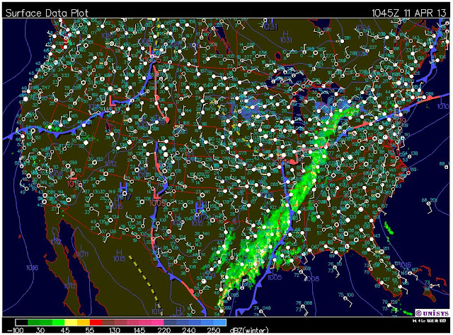
Today there is a 100% chance of precipitation in several forms. We will expect snow, freezing rain, and sleet before 2pm, then rain and sleet between 2pm and 3pm, then rain mixed with snow and freezing rain after 4pm. ICKY!!!!! As we can see from the surface map below the low pressure system located over Illinois is really sucking the moisture over to us; along with the help from the low pressure system on the east coast. We can also see the cold front in the south is creating a lot of precipitation that is coming all the way up to Michigan from Texas.
Again, we can see the jet stream shows were adjacent air masses with significant temperature differences are coming together. This steep gradient in the jet stream matches the cold front location on the surface map above where the precipitation is taking place from south to north.
The temperature map is just another illustration of where these temperature differences are taking place.
Tonight's forecast calls for a 90% chance of precipitation in the form of rain and freezing rain with a possible mix of snow before 11pm, the snow possibly mixed with freezing rain between 11am and 2am, then just snow after 2am. Winds will be coming from the NE around 10-15 mph, with gusts around 25 mph. The low will be 28F. New snow accumulation is expected to be 1-3 inches.


No comments:
Post a Comment